4.04 Uses
4.06 Site Plans And Building Design
4.08 Development Standards
4.10 Design Guidelines
The Forge Mixed Use (“MU”) District is intended to encourage a mixture of commercial, office and residential uses within an urban neighborhood atmosphere. Development in the Forge MU District is intended to provide a pedestrian oriented, safe and attractive streetscape, and a controlled and compatible setting for residential and commercial development. The standards are intended to achieve established objectives for urban and traditional design, pedestrian amenities and land use regulation.
Permitted uses in The Forge MU District shall be those specified in VZC 15.12.050 "Table of Allowed Uses in Non-Residential Zoning Districts", as attached and amended.
It is intended that development in The Forge MU District (Figure: The Forge MU District Boundary Map) will be subject to the following standards and regulations and Design Guidelines (VSP 4.10 – Design Guidelines).
This will be accomplished by the following procedures:
- Individual Subdivision Plats and Site Plans. A site plan for each parcel shall be submitted for review and approval by Vineyard in accordance with VZC 15.28 – Permitted Uses. Individual site plans shall include a demonstration of how the proposed project will be consistent with The Forge MU District and Design Guidelines, including the following:
- The proposed architectural and site design concepts including style, colors, type of materials and placement of structures.
- A description of the landscaping treatment, plant materials, fences, walls and other open space improvements.
- The proposed architectural and site design concepts including style, colors, type of materials and placement of structures.
- Amendments to the Master Development Plan
- Minor Amendments
- Minor amendments are those that increase by ten percent (10%) or less any individual element shown in the Forge MU District to achieve a more suitable development plan.
- Minor amendments do not allow an increase in the maximum building height or to the maximum residential intensity or non-residential intensity.
- The Vineyard Planner shall be the approval authority for minor amendments.
- Minor amendments are those that increase by ten percent (10%) or less any individual element shown in the Forge MU District to achieve a more suitable development plan.
- Major Amendments
- Major amendments are those that increase the maximum allowable building height, maximum residential density, maximum non-residential intensity, and/or that exceed ten percent (10%) of an individual Forge MU District element.
- Approval of any major amendments will require review approval of the Vineyard City Council upon a recommendation from the Planning Commission following the process for zoning ordinance text amendments set forth in the Vineyard Zoning Ordinance.
- Major amendments are those that increase the maximum allowable building height, maximum residential density, maximum non-residential intensity, and/or that exceed ten percent (10%) of an individual Forge MU District element.
- Minor Amendments
Figure: The Forge MU District Boundary Map

- Project Characteristics. The Forge MU District shall have the following characteristics:
- Multiple buildings, each of which may accommodate one or more uses;
- Buildings on the site are expected to be connected by internal streets and/or drives, and/or pedestrian connections and pathways; and,
- Public spaces, such as plazas, parks, squares or other types of gathering space.
- Minimum Acreage. The minimum acreage for application of The Forge MU District is 5 acres.
- Residential Intensity. The quantity of residential uses approved or constructed shall never exceed one half (1/2) of the quantity of non-residential uses approved or constructed, as measured in total floor area (square feet).
Ancillary uses that directly support residential development are considered residential uses for calculation purposes. Ancillary uses that are shared between residential and non-residential uses shall be calculated proportionately. - Non-Residential Intensity. There is no limit on the intensity of non-residential development as along as each development complies with the development standards of The Forge MU District, any other applicable Vineyard Ordinances and the requirements herein.
- Building Height. (see VSP 4.10 – Design Guidelines)
- Setbacks. Minimum and maximum front or side setback requirements are specified in the Design Guidelines (VSP 4.10 – Design Guidelines). Building components, such as awnings or signage are permitted to encroach beyond the setback.
- Compatibility Requirements. Development within The Forge MU District shall be compatible with, and preserve the character and integrity of adjacent land uses. Each development shall include improvements or modifications, either on-site or within the public rights-of-way, to mitigate adverse impacts, such as traffic, noise, odors, shadow, scale, visual nuisances or other similar adverse effects on existing adjacent land uses. These improvements or modifications may include, but shall not be limited to the placement or orientation of buildings and entryways, parking areas, buffer yards, the alteration of building mass, and the addition of landscaping, walls, or both.
- Mixed Use Requirements
- Mixed-use development is a development in which land uses are mixed vertically and/or horizontally (such as with existing or planned adjacent land uses) which promote easy access by pedestrians. The Forge MU District shall comply with the following standards:
- Each development or project area shall connect to and be compatible with any adjacent development or project area.
- Individual project areas shall provide a comprehensive pedestrian network of parks, plazas and other open space elements that connect uses. Open space areas and the paths that link them shall facilitate the integration of adjacent land uses on the site.
Specifically, onsite pedestrian connections shall be provided to and between the following points:- The primary entrance or entrances to each building;
- Existing or planned transit stops, stations, and park-n-ride locations;
- On-site amenities; and
- Adjacent development.
- Open Space. The Forge MU District shall provide open space within the development as follows:
- Plazas, parks, city squares, or other gathering spaces designed and located for substantial use. At least one gathering space should include a significant public amenity, such as water features and/or public art.
- A minimum of twenty percent (20%) of the net site area of the development shall be set aside for open space with the possibility of reducing it to not less than ten percent (10%) through open space enhancements. Such areas shall be used for plaza areas, outdoor seating areas, pedestrian ways, landscape areas, recreation areas, or other similar uses as approved by the Vineyard Planner.
Bonuses in the form of open space reductions may be awarded for up to ten percent (10%) of the net site area as follows:- 2% for pedestrian plaza’s and passageways finished with decorative paving, benches and creative bicycle racks.
- 2% for the installation of decorative street lights and directional signage along pedestrian plaza’s and passageways.
- 1% for the installation of public art.
- Up to 5% for equivalent square foot for equivalent square foot landscaping of adjacent offsite properties.
- All open space areas shall be owned and maintained by a property owners association or landowner. Areas greater than 5 acres in size may be dedicated to the Vineyard upon approval of the Vineyard City Council.
- Parking
- Given the mixed-use nature of the Forge MU District and the desire to accommodate a range of uses in any building over time, off-street parking at the Forge MU District will be governed by the following requirements:
Table: Minimum Parking RequirementsUse Minimum Parking Requirement Non-Residential An average of 3 spaces per 1,000 square feet gross building floor Residential An average of 1.5 spaces per dwelling unit - Shared Parking: Shared parking allows a reduction in the total number of required parking spaces when a parcel is occupied by two or more uses which typically do not experience peak parking demands at the same time. When any land or building is used for two or more uses that are listed below, the minimum total number of required parking spaces may be determined by the following procedures:
- Multiply the minimum required parking for each individual use, excluding spaces reserved for use by specified individuals or classes of individuals (except car share programs), by the appropriate percentage listed in Table: Shared Parking, for each of the designated time periods.
- Calculate a sum for all uses for each of the five time periods (columns). The minimum parking requirement is the highest of these sums. Table: Illustrative Shard Parking Credit Calculation, provides an example of how to use Table: Shared Parking, to calculate required parking.
- All parking stalls associated with a land use, whether shared or individually reserved, shall be located on the same block as the use for which they are intended.
Use Weekday Weekend Night
(12 AM to 6 AM)Day
(6 AM to 6 PM)Evening
(6 PM to 12 AM)Day
(6 AM to 6 PM)Evening
(6 PM to 12 AM)Residential 100% 60% 90% 80% 90% Office 5% 100% 10% 10% 5% Retail/Commercial 5% 70% 90% 100% 70% Commercial Lodging 80% 80% 100% 50% 100% Restaurant 10% 50% 100% 50% 100% Entertainment 10% 40% 100% 80% 100% All Others 100% 100% 100% 100% 100% - Source: Centennial CO Land Development Code 12-5-29-06
Source: Centennial CO Land Development Code 12-5-29-06EXAMPLE: A mixed-use building has 50 2-bedroom residences, 50,000 square feet of office space, and 50,000 square feet of retail space. Separately, these uses would require 450 parking spaces ((50 sp. x 2 sp. / unit) + (50,000 sf. x (1 sp. / 250 sf.)) + (50,000 sf. x (3 sp. / 1,000 sf.)) = 450). However, combined, they could share 350 parking spaces. Use Weekday Weekend Night
(12 AM to 6 AM)Day
(6 AM to PM)Evening
(6 PM to 12 AM)Day
(6 AM to 6 PM)Evening
(6 PM to 12 AM)Residential 100 spaces 100% x 100 = 100 60% x 100 = 60 90% x 100 = 90 80% x 100 = 80 90% x 100 = 90 Office 150 spaces 5% x 150 = 8 100% x 150 = 150 10% x 150 = 15 10% x 150 = 15 5% x 150 = 8 Retail/Commercial 200 spaces 5% x 200 70% x 200 = 140 90% x 200 = 180 100% x 200 = 200 70% x 200 = 140 Commercial Lodging 80% x 0 = 0 80% x 0 = 0 100% x 0 = 0 50% x 0 = 0 100% x 0 = 0 Restaurant 10% x 0 = 0 50% x 0 = 0 100% x 0 = 0 50% x 0 = 0 100% x 0 = 0 Entertainment 10% x 0 = 0 40% x 0 = 0 100% x 0 = 0 80% x 0 = 0 100% x 0 = 0 All Others 100% x 0 = 0 100% x 0 = 0 100% x 0 = 0 100% x 0 = 0 100% x 0 = 0 COLUMN TOTALS 118 3501 285 295 238 TABLE NOTE:
1The largest number, 450, is the number of parking spaces that are required. This example is a 22 percent reduction compared to individual calculations. - Conversion of Parking Lots to Structures: It is anticipated that surface parking lots may be provided in the initial phases of development, in many cases to eventually be replaced by structured parking. No surface parking lot shall be constructed within fifty feet (50') of any street intersection, or between any building and street property line.
- Given the mixed-use nature of the Forge MU District and the desire to accommodate a range of uses in any building over time, off-street parking at the Forge MU District will be governed by the following requirements:
- Landscaping. Each project shall be consistent with the Design Guidelines for The Forge MU District and the landscape provisions of the Vineyard Zoning Code.
The following Design Guidelines have been adopted for The Forge MU District. No project shall be approved until design and landscaping standards are submitted to and approved by the Vineyard City Council per the process set forth in this Title.
- Introduction. The Forge MU District is approximately 45 acres located on the southwest corner of Vineyard Connector and Mill Road. The proposed project will consist of up to 1.8 million square feet of building space including retail, services, offices, medical, entertainment and hotels. It will also contain a range of residential uses in order to provide vitality day and night, and opportunities to live close to work and to accommodate the multiple housing needs of the region.
The Forge MU District is intended to complement the adjacent Megaplex commercial development and to jointly provide dining, entertainment and convenience for both workers, visitors, and residents.
The Forge MU District will be implemented over time by a variety of individual builders. The urban design framework for The Forge MU District will guide future development to ensure consistency and a high level of urban design quality (Figure: Urban Design Framework). To be successful as a high energy, high density center, it will be important that fundamental principles of good urban design be followed in each project.
The following Design Guidelines are intended to foster a rich urban environment that will assure The Forge MU District retains a human scale through change, contrast, intricacy, color and materials. Block structure, building massing and architectural character will define a private realm that will shape public space, offer additional connectivity, frame views and celebrate key gathering places. The streets, plazas and parks of the public realm will foster lively pedestrian activity, support commercial vitality and facilitate community pride. - Design Intent. The general, overall character of The Forge MU District should reflect the multi- layered history of the site (Figure: Vision Mosaic). This character will bring about a familiar, traditional setting for users while allowing a diversity of building styles that is both timeless and contemporary.
- Urban Design Framework. The Urban Design Framework (Figure: Urban Design Framework), is a summary of the key physical constraints and building placement objectives that are described in subsequent Figures.
- Block Structure
- Block Size: Typical block size will not exceed 500’ in length with the length of the block running along an east-west axis to ensure the maximum potential for south-facing facades (Figure: Block Structure).
- Mid-Block Alleys and Passages: The walkability of a community is defined by how well the pedestrian network is connected. To ensure a high walkability for The Forge MU District, mid-block alleys and passages are envisioned to break down block scale allowing for greater accessibility for both pedestrian and automobile circulation (Figure: Pedestrian Circulation).
- Continuous Building Frontage: A continuity of building frontage, not interrupted by parking lots or deep setbacks, encourages a more active involvement between building uses and pedestrians. Blocks B, C, E and F shall have continuous building frontage which will include not less than eighty percent (80%) of the block length or at least seventy-five percent (75%) of the total block perimeter of these blocks. (Figure: Building Frontage and Build-to Zone).
- Ground Floor Building Setback: The street frontage of all habitable buildings shall be built within the designated zero foot (0’) minimum and ten foot (10’) maximum front setback (“Build-to Zone”) from the right of way to support a strong, continuous “street wall” to reinforce an urban form. Exceptions may be made for publicly accessible outdoor plazas. [Note: The maximum building setback may be increased along major streets such as Mill Road or Geneva Road to provide additional buffering of pedestrians from busy traffic.]
- Side and Rear Setbacks: There shall be no minimum side setback requirement from property lines. Rear setbacks along alleys shall range from zero feet (0’) adjacent to pedestrian ways to five feet (5’) adjacent to travel lanes.
- Building Height and Stepbacks: Buildings can range from a minimum of twenty feet (20’) to a maximum of one hundred-twenty five feet (125’) for flat roofs or one hundred forty feet (140’) for pitched roofs. Any stories above the fourth story should stepback a minimum of ten feet (10’) from the right of way line (Figure: Building Stepback).
- Side and Rear Setbacks: There shall be no minimum side setback requirement from property lines. Rear setbacks along alleys shall range from zero feet (0’) adjacent to pedestrian ways to five feet (5’) adjacent to travel lanes.
- Perceived Building Length: Individual buildings along the street edge should not appear to exceed one hundred fifty feet (150’). If a longer building is necessary, its perceived length should incorporate stepback or material changes (Figure: Maximum Building Length between Insets).
- Block Size: Typical block size will not exceed 500’ in length with the length of the block running along an east-west axis to ensure the maximum potential for south-facing facades (Figure: Block Structure).
- Building Orientation and Climate Protection
- Energy and Climate Orientation: Buildings are highly encouraged to include passive solar and passive wind strategies (Figure: Building Design Maximizing Solar Access).
- Protective Porticos and Awnings: Architectural elements that provide shade are encouraged to provide pedestrians a pathway that is enjoyable to use year round and foster walking and social interaction. The climate in Utah Valley is such that in the summer months shade is preferred, and in the winter months protection from snow is preferred. Awnings that extend over the public right of way require a revocable permit and shall have at least eight feet (8’) clearance above the adjacent sidewalk at all points, and shall not extend more than six feet (6’) into the public right-of-way.
- Energy and Climate Orientation: Buildings are highly encouraged to include passive solar and passive wind strategies (Figure: Building Design Maximizing Solar Access).
- Ground Floor Activation
- Transparency: The first floor elevation facing a street shall not have less than sixty percent (60%) transparent surfaces. All first floor glass will be non-reflective. Display windows that are three-dimensional and are at least 2 feet deep are permitted and may be counted toward the sixty percent (60%) transparency requirement. If the ground level of a building is occupied by residential uses, the sixty percent (60%) transparency requirement may be reduced to thirty-five percent (35%) (Figure: Bottom Floor Glass Surface Transparency). Upper floors will maintain a minimum of thirty-five percent (35%) transparency.
- Entrances: Provide at least one operable building entrance per elevation that faces a public street. Buildings that face multiple streets are only required to have one door on either street.
- Wall planes: The maximum length of any continuous ground floor wall surface, uninterrupted by a change in material, setback or protrusion, will be thirty feet (30’).
- Screening: All building equipment and service areas, including on-grade and roof mechanical equipment and transformers that would be visible from the public right of way, shall be screened from public view, or enclosed as to appear to be an integral part of the architectural design of the building (Figure: Roof Equipment Screening).
- Transparency: The first floor elevation facing a street shall not have less than sixty percent (60%) transparent surfaces. All first floor glass will be non-reflective. Display windows that are three-dimensional and are at least 2 feet deep are permitted and may be counted toward the sixty percent (60%) transparency requirement. If the ground level of a building is occupied by residential uses, the sixty percent (60%) transparency requirement may be reduced to thirty-five percent (35%) (Figure: Bottom Floor Glass Surface Transparency). Upper floors will maintain a minimum of thirty-five percent (35%) transparency.
- Architectural Character and Materials
- Building Character Organization: All buildings shall generally have a “base, middle, and top” character to avoid monotonous uniformity of single-material building walls. Differentiating buildings into these three components gives human scale and variety through change, contrast, and intricacy in facade form, color and/or material. Other scaling elements such as insets and projections are encouraged to break up flat or monotonous facades (Figure: Base, Middle, and Top Building Character).
- Exterior Three-Dimensional Details: Three-dimensional details are encouraged along the publicly-visible exterior of buildings, including:
- Cornices, fascia, visible substantial window sills and headers, projecting bay windows, inset doors and windows and balconies (Figure: Building Exterior 3D Details).
- Recessed windows (all windows are encouraged to be recessed a minimum of three inches)
- Cornices, fascia, visible substantial window sills and headers, projecting bay windows, inset doors and windows and balconies (Figure: Building Exterior 3D Details).
- Building Materials: All materials shall be durable in nature and build on the multi layered history of the site. The following is a non-exhaustive list of materials that would meet this objective:
- Sandstone-based brick material - this is desired as a base material for the entire development and is of regional significance to the area;
- Brick with accent banding and symbols of various colors and patterns (Figure: Brick Building with Accent Banding);
- Visible steel support such as I-beam columns and spandrels, steel cable or rod suspension, decorative steel railings (Figure: Building with Visible Steel Support);
- Corrugated steel siding (Figure: Building with Corrugated Steel Siding);
- Concrete foundations, columns, lintels, sills, loading docks (Figure: Building with Concrete Loading Dock Frontage);
- Large expanses of multi-paned glass windows, glass block, large display windows, skylights, greenhouses (Figure: Building with Multi-paned Glass Windows);
- Heavy wood timber columns and spandrel beams (Figure: Building with Heavy Wood Timber Columns); and
- Wood, stone, corrugated metal, etc.
- Local materials are encouraged, whether as reclaimed materials from nearby projects or manufactured locally and support sustainable building practices.
- Other materials can be considered to minimize costs while achieving a similar aesthetic (e.g., concrete with an applied texture versus a brick wall) while out-of-character materials will be considered in special circumstances - such as iconic architecture - to bring additional variety and contemporary influences.
- Sandstone-based brick material - this is desired as a base material for the entire development and is of regional significance to the area;
- Iconic Architectural Elements: Selected use of iconic architectural elements is encouraged at key locations that serve as focal points for the district. Examples might include:
- Tower buildings fronting open spaces, plazas, or other gathering spaces (Figure: Iconic Tower Building with Park Space).
- Architectural signage and marquees (Figure: Iconic Marquee Sign).
- Tower buildings fronting open spaces, plazas, or other gathering spaces (Figure: Iconic Tower Building with Park Space).
- Gateway Buildings: Buildings at major road intersections and gateways carry additional significance and should have the highest design quality.
- These buildings should present front facades and entries to the public, and should incorporate visible public gathering spaces and provide the visual interest to frame the intersection.
- Building corners fronting onto intersections should be defined with appropriate retail uses and architectural treatment. Gas station canopies, fast-food restaurants with drive-thrus and other services shall not be allowed in these locations.
- These buildings should present front facades and entries to the public, and should incorporate visible public gathering spaces and provide the visual interest to frame the intersection.
- Building Character Organization: All buildings shall generally have a “base, middle, and top” character to avoid monotonous uniformity of single-material building walls. Differentiating buildings into these three components gives human scale and variety through change, contrast, and intricacy in facade form, color and/or material. Other scaling elements such as insets and projections are encouraged to break up flat or monotonous facades (Figure: Base, Middle, and Top Building Character).
- Signage. (RESERVED)
- Lighting
- Street Lights: Consistent street light fixtures will be used throughout The Forge MU District for both automobile and pedestrian safety.
- Architectural Lighting: Building illumination will be limited to:
- Highlighting of specific building features
- Building and ground floor business names
- Lighting of public walkways
- Lighting of architectural features above the ground floor
- Highlighting of specific building features
- Street Lights: Consistent street light fixtures will be used throughout The Forge MU District for both automobile and pedestrian safety.
- Streets
- Prototypical Sections and Plans:
- Commercial Street (Figure: Commercial Street Section and Figure: Commercial Street Plan)
- Retail “Stroll Street” (Figure: Retail "Stroll" Street Section and Figure: Retail "Stroll" Street Plan)
- Frontage Street (Figure: Frontage Street Section)
- Alley (Figure: Alley Street Section)
- Commercial Street (Figure: Commercial Street Section and Figure: Commercial Street Plan)
- Roadways: The portion of the right of way - from flow line to flow line - is envisioned to accommodate parallel and/or diagonal parking lanes on either side of the street adjacent to the outside edge of two travel lanes - one in each direction.
- Bulb-outs/Flush Curbs/Bollards: These items help to facilitate pedestrian and automobile circulation through universal design, and are envisioned to occur in the parking lane at intersections and at mid-block crossings where strong desire lines occur (Figure: Flush Curbs on Street).
- Crosswalks and Mid-Block Crossings: On private streets, crosswalks will be ten feet (10’) minimum in width and will occur no greater than three hundred (300’) apart along any block. Crosswalks should include two directions at every corner (Figure: Crosswalks at every Corner). On public streets, crosswalks shall be located and constructed in accordance with adopted City Standards.
- Sidewalks: Sidewalks serve multiple purposes within an urban environment and should incorporate different activities including seating, outdoor dining, lighting, trash and recycling receptacles, bus stops and shelters, newsstands, utility boxes and shade trees between pedestrian walkways and traffic. A minimum eight feet (8’) ADA accessible, unobstructed pedestrian walkway is required.
- Pedestrian Zone – Five feet to nine feet (5’-9’) in width, this portion of the sidewalk occurs adjacent to the furniture zone and is intended to provide a comfortable clear path of travel for pedestrians.
- Activity Zone – Four feet to seven feet (4’-7’) in width, this portion of the sidewalk is adjacent to the building edge and is intended to provide an activity zone for commercial businesses to serve customers or show their wares on the street.
- Pedestrian Zone – Five feet to nine feet (5’-9’) in width, this portion of the sidewalk occurs adjacent to the furniture zone and is intended to provide a comfortable clear path of travel for pedestrians.
- Prototypical Sections and Plans:
- Interior Block Connections (Alleys)
- Prototypical Alley Section: Alley rights of way can range in width between thirty and forty feet (30’-40’) feet (Figure: Alley Street Section).
- Multi-Purpose Connections: Alleys are encouraged to provide necessary connections for service/delivery, fire protection and pedestrian access. Since alleys and interior connections are envisioned to accommodate off-street loading as well as serve as pedestrian connections the following includes preferred and minimum guidelines:
- Preferred Guidelines
- Roadway - Twenty-one foot (21’) unobstructed automobile pathway (which combined with the adjacent rear-yard building setback provides twenty-six feet (26’) clear for fire equipment).
- Sidewalk – 10-16 feet wide, consisting generally of:
- Pedestrian Zone – Six to ten feet (6’-10’) wide
- Furniture Zone – Four to six feet (4’-6’) wide (for shade trees, benches, trash cans, lighting).
- Pedestrian Zone – Six to ten feet (6’-10’) wide
- Roadway - Twenty-one foot (21’) unobstructed automobile pathway (which combined with the adjacent rear-yard building setback provides twenty-six feet (26’) clear for fire equipment).
- Minimum Guidelines
- Roadway – Twenty one foot (21’) unobstructed vehicular way
- Sidewalk – Five foot (5’) unobstructed pedestrian way
- Roadway – Twenty one foot (21’) unobstructed vehicular way
- Comparison of Road Standards: Table: Road Standards below illustrates how the road standards for The Forge MU District are consistent with those of the Downtown Vineyard Special Purpose District.
Table: Road StandardsSide Street Requirements (Downtown Vineyard) The Forge Permitted Districts All Districts All Districts Permitted Adjacent Building Types See Building section N/A Typical Right-of-Way Width 61' to 81' 70' to 75' Vehicular Realm Travel Lanes 1 land in each direction 1 lane in each direction Lane Width 11' - 13' 11' - 13' Allowable Turn Lanes NA Yes on Retail "Stroll" Streets Parking Lanes Parallel required on both sides of street. Parellel required on both sides of the commercial streets.
Diagonal allowed on one side with Parallel on the other side of retail streets.Pavement Width 18' - 22' on each side of centerline 18' - 20' on each side of centerline for commercial streets.
18' - 20' on flush side, and 27' - 29' on podium side of Retail "Stroll" Streets.Bicycle Facilities Shared Bike Lanes Shared Bike Lanes Pedestrian Realm Pedestrian Facilities 6' - 10' Sidewalk
(10' on Main Street)17' Sidewalk on Commercial Streets.
12' - 16' Sidewalk on flush side, and 14' Sidewalk on podium side of Retail "Stroll" Streets.Street Buffer Park strip between sidewalk and protected bike lane varies depending on street tree size, 6' - 8'+. Allowes for trees, bike racks, planter beds, street furnishings and lights. Parking Lane, and Furniture Zone provide buffer between Pedestrian Zone and Travel Lanes on the Commercial Street Diagonal Parking Lane, provides buffer between Pedestrian Zone and Travel Lanes on the Retail "Stroll" Street.
- Preferred Guidelines
- Overhead and Underground ROW: Developments that include interior alleys or service lanes - whether dedicated or privately owned with a public easement - may use the overhead and underground right-of-way of the new mid-block street as part of their developable area, subject to design evaluation and approval of the final legislative authority.
- Service and Storage: Consideration should be given to loading, delivery and transfer of merchandise, garbage collection, recycling, fire and utilities. Loading areas should be provided when appropriate. However, these functional needs should not compromise the visual character of the overall development or adjacent properties and will be subject to design evaluation and approval of the final legislative authority.
- Drive-thru Lanes: Typical drive-thru lanes break up the continuity of block building facades and conflict with pedestrians. Drive-thru facilities at The Forge will be subject to careful design evaluation and approval of the final legislative authority. Any drive-thru lanes adjacent to roadways in The Forge are encouraged to be designed with one or more of the following conditions:
- Be limited to 3 bays or less
- Occur at the end of a block façade
- Be masked within a building form
- Feed into a single exit lane
- Be screened from view through a combination of low screen walls (“knee walls”), berming, and landscaping.
- Be limited to 3 bays or less
- Screening: Screening techniques should be utilized throughout The Forge MU District for any activity or storage that should be kept from public view. This may include any combination of building design, landscaping and berming, and/or location and will be subject to design evaluation and approval of the final legislative authority. Typical areas that should require screening may include:
- Outdoor Storage
- Refuse Containers
- Surface Parking
- Loading Areas (adjacent to roadways)
- Outdoor Storage
- Enclosures: Enclosures should be located to provide easy access for users, adequate space for servicing by refuse trucks, and visibility for safe vehicle circulation.
- Enclosure materials and colors should be consistent with, and complementary to, building materials and finishes.
- Refuse containers should be conveniently located throughout the project, yet sufficiently buffered from project entries, main building entries, and main pedestrian paths.
- Enclosure materials and colors should be consistent with, and complementary to, building materials and finishes.
- Prototypical Alley Section: Alley rights of way can range in width between thirty and forty feet (30’-40’) feet (Figure: Alley Street Section).
- Parking
- On-Street Parking: The Forge MU District will provide on-street parking along all streets:
- Parallel parking will occur along all streets throughout the development.
- Diagonal parking will be an optional element of the “Stroll Street” condition where elevated sidewalks atop podium parking (sub-grade parking facilities) may occur (Figure: Retail "Stroll" Street Section and Figure: Retail "Stroll" Street Plan).
- Parallel parking will occur along all streets throughout the development.
- Sub-grade Parking Facilities: No special design and setback restrictions will apply to parking facilities built below grade.
- Parking Structures: Parking structures are envisioned as the primary parking strategy for The Forge MU District and will meet the following conditions:
- Unbundled parking will be provided as an option for development at the block level and will accommodate all potential uses
- Structures, in general, will be located in block interiors behind principal buildings
- Structures adjacent to street rights-of-way will maintain the continuity of the pedestrian experience along the ground level by providing either:
- Wrapped retail, offices and/or restaurants to maintain an active ground-floor edge;
- Liner retail (e.g., shallow building that can house news stand, flower shop, small offices, etc.); or
- Façade articulation or screening that masks the parking interior.
- Wrapped retail, offices and/or restaurants to maintain an active ground-floor edge;
- Unbundled parking will be provided as an option for development at the block level and will accommodate all potential uses
- On-Street Parking: The Forge MU District will provide on-street parking along all streets:
Figure: Vision Mosaic  Figure: Urban Design Framework
Figure: Typical Block Structure  Figure: Pedestrian Circulation
  Figure: Building Frontage and Build-to Zone
 Figure: Building Height Stepback
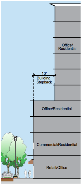 Figure: Maximum Perceived Building Length
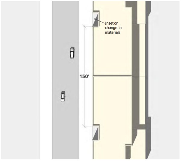 Figure: Building Design Maximizing Solar Access
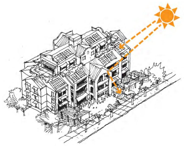 Figure: Bottom Floor Glass Surface
 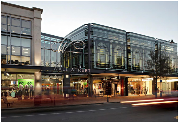 Figure: Roof Equipment Screening
 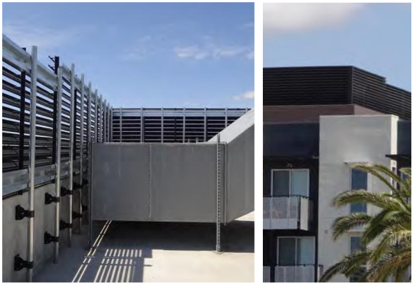 Figure: Base, Middle and Top Building Character
 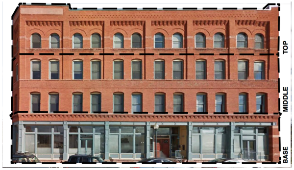 Figure: Building Exterior 3D Details
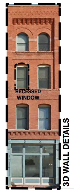 Figure: Brick Building with Accent Banding
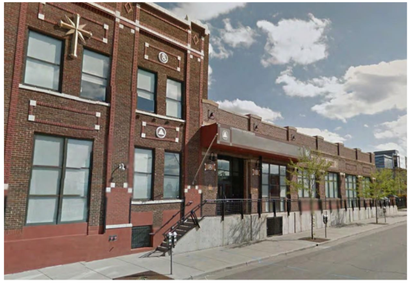 Figure: Building with Visible Steel Support
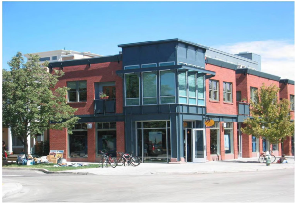 Figure: Building with Corrugated Steel Siding
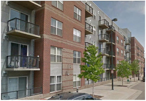 Figure: Building with Concrete Loading Dock Frontage
 Figure: Building with Multi-Paned Glass Windows
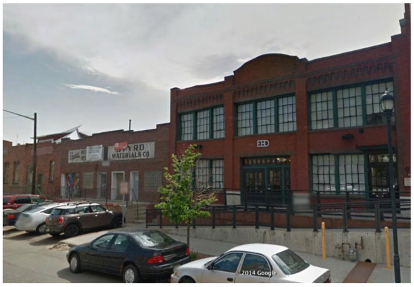 Figure: Heavy Wood Timber Columns
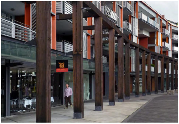 Figure: Iconic Tower Building with Park Space
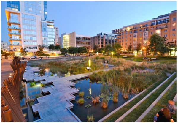 Figure: Iconic Marquee Sign
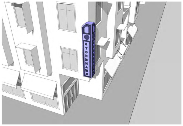 Figure: Commercial Street Section
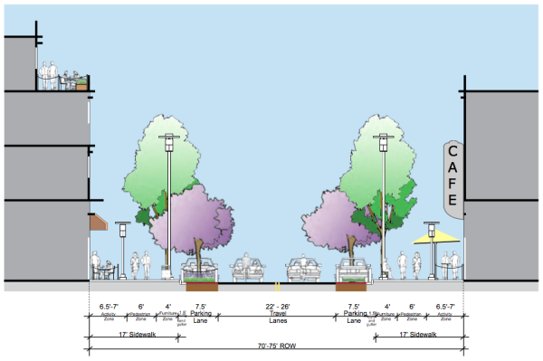 Figure: Commercial Street Plan
 Figure: Retail "Stroll" Street Section
 Figure: Retail "Stroll" Street Plan
 Figure: Frontage Street Section
 Figure: Alley Street Section
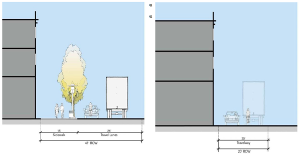 Figure: Flush Curbs on Street
 Figure: Crosswalks at every Corner